Central Texas is bracing for significant flash flood risks this week as heavy rainfall intensifies. The National Weather Service has issued a Flash Flood Warning for multiple counties, signaling an imminent threat of dangerous water accumulation within hours. This is not an isolated event but part of a larger, persistent weather pattern that has been disrupting the region for days.
Early Friday brought record-breaking rainfall to San Antonio, with some areas receiving over 5 inches of rain in just a few hours. This dramatic increase in precipitation has already triggered minor flooding in several neighborhoods, highlighting the vulnerability of infrastructure and communities that are often unprepared for such rapid changes in weather.
Why is this happening now?
The current situation stems from a stalled weather system over the southern U.S. that has been pumping massive amounts of moisture into the region. This slow-moving storm complex has been moving across the state for several days, creating a perfect storm for extreme rainfall. Meteorologists describe this as a 'coastal ridge' effect, where warm, moist air from the Gulf of Mexico is trapped over central Texas, leading to prolonged and intense downpours.
It's important to note that flash floods are not just about the volume of rain but how quickly it can accumulate. When heavy rain falls on already saturated ground, water cannot absorb quickly enough, causing rivers and streams to overflow their banks rapidly.
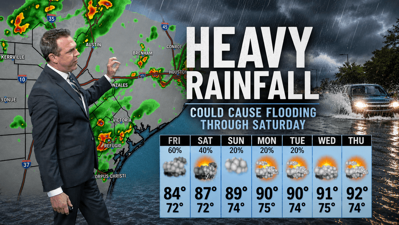
What's the timeline?
- Friday: Peak rainfall expected in central and eastern parts of the state, with the highest risk in San Antonio and surrounding areas.
- Saturday: Showers and thunderstorms will continue to linger, potentially causing additional localized flooding.
- Long-term impact: If the weather pattern persists, this could lead to widespread damage to roads, homes, and infrastructure.
Residents should be aware that even if they live in a low-risk area, flash flooding can occur unexpectedly. This is especially true in urban areas with aging drainage systems that are not designed to handle sudden, intense rainfall.
The National Weather Service has urged immediate action for those in the affected zones. It's recommended that residents avoid low-lying areas, check their drains for blockages, and prepare emergency kits with essential supplies. The key to safety is to act quickly and stay informed through official channels.
Historically, Central Texas has faced similar challenges during the spring and summer months. For example, in 2015, a similar weather pattern caused significant flooding in the same regions, leading to over 200,000 people being displaced and $1 billion in damages. This year’s situation is particularly concerning given the recent history of climate change impacts on the region.
As the weather continues to evolve, it's crucial for communities to be prepared and proactive. Local emergency services are on high alert, and residents are encouraged to monitor their local news and weather updates for real-time guidance.